By Bill Seymour Special to the Independent Apr 2, 2022
It’s an ambiguous and contentious line in the sand.
The state constitution guarantees the right to ocean access for the public. But private landowners claim their beachfront property rights exclude the public.
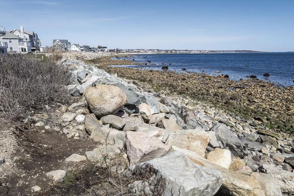
State law draws the line within which the public must stay when they access a shore fronting private property. But that line, which has long been murky and hard to locate, needs to be higher and drier – about 10 feet above the high-tide line – to be useful for the public, according to a special legislative commission issuing a report this week.
A new law proposed last week adopts this recommendation. It will first be considered by the House of Representatives and any approval moves it to the state senate and the governor for consideration.
Activists on both sides are already lobbying legislators. With access advocates on one side, and homeowners on the other, the sides are fighting over where this mark in the sand goes.
“Basically it (the proposal) doesn’t let people walk across a bulkhead or front yard, only just along sandy and rocky shorelines,” Rep. Blake Filippi said.
His district, which includes Block Island, Charlestown and parts of South Kingstown and Westerly, has plenty of beaches and he doesn’t see this change infringing on property rights of oceanfront homeowners.
Those homeowners see a different view from their windows – what was formerly an exclusive private beach would become de facto public property.
“We believe when applying Rhode Island and U.S. Supreme Court decisions this amounts to a taking of private property. When property is taken, government needs to compensate,” said Chris Boyle, an attorney and lobbyist representing a group of property owners opposed to changing current law.
Their group is called Shoreline Taxpayers Association for Respectful Traverse, Environmental Responsibility and Safety Inc.
Filippi responded that right now the constitutional rights to the public access are “illusory” because the court-defined area is underwater around most beaches. The legislature is defining for the first time where the usable area should be to conform with a constitutional right to it, he added.
The Rhode Island State Constitution says in part that people are guaranteed a right to “enjoy and freely exercise all the rights of fishery, and the privileges of the shore, to which they have been heretofore entitled under the charter and usages of this state, including but not limited to fishing from the shore, the gathering of seaweed, leaving the shore to swim in the sea and passage along the shore.”
There’s nothing in those words or the rest of Article I, Section 17, that defines how far inland those rights are in effect.
In stepped the courts over three decades ago to define a place. A judicial ruling set the access line as the mean high-tide mark over 18.6 years.
The conflict
“God bless if you can go to the end point to where the average mean high tide line is over 18.6 years,” exclaimed Filippi when discussing the matter three years ago.
Those comments came after a shoreline access advocate was arrested for trespassing while walking the beach. The South Kingstown Police Department later dismissed the charges, deciding that the impracticable definition in the law was too hard to enforce.
Around the same time, one homeowner hired a security guard to keep watch and report stray loiterers on her beach.
The controversy led to a legislative commission whose recommendation were released this week. The panel heard testimony from citizens, advocates, experts in law, sea and beach erosion.
It reached a recommendation that a more definite – and dry – spot at the actual high tide line plus 10 feet, was necessary to guarantee access to the water. But it will take passage by the General Assembly for that recommendation to take effect.
“The legislature for the first time would actually decide on how to make that realistically happen,” said Filippi, who is sponsoring the bill.
But according to the group representing private homeowners, re-drawing the access line amounts to a state expropriation of their property.
“We think this is a major encroachment,” said Boyle. “It’s nothing different than if the state wanted to build a highway and took someone’s property. And the state would have to pay for it,” he added.
“I think any reasonable person would assume that would be an astronomical figure when you look at the amount of shoreline we have in Rhode Island,” he said.
Boyle’s group is planning a legal challenge if the change is adopted into state law.
Filippi says that the state constitution requires access to at least some portion of land. “I would like to know where Mr. Boyle thinks the line should be. Given where it is now, he doesn’t have even a reasonable position. It’s underwater at most beaches.”
Public Right of Ways
Having the right to walk along the beach is different than the right to enter the beach. This is where public right-of-ways add another twist to the problem.
Many shoreline access points, semi-secret footpaths established when waterfront neighborhoods were a hodgepodge collection of humble summer cottages, now abut multi-million dollar mansions.
The 2019 protest over beach access rights also drew in the controversy and questions about rights-of-way to those beaches.
“The more land development there has been, and now more homes in summer communities, the secret right of ways that people once used are the object of complaints from people with more money who have fixed up these homes,” said Rob Lyons, chairman of Charlestown’s Coastal Pond Management Commission.
Local towns, such as Narragansett, Charlestown, South Kingstown, North Kingstown and East Greenwich, all now have increased interest and complaints about various public rights of way, marked, unmarked and needing improvement.
They all have public panels to determine boundaries and what slices of land belongs to the town or public trust and what is owned by a private property owner. Along with this will come rules regarding parking and congregating at those sites.
The University of Rhode Island Sea Grant Institute has reviewed this issue. One assessment pointed out that “the integration of (rights of way) into neighborhoods can spark protests of “NIMBY,” or “Not In My Backyard,” it said.
Residents often raise concerns with an easement’s maintenance needs and the potential bad behavior of visitors, such as noise, dog waste, litter, and disregard for danger.
At the core of these conflicts is fear of change in general and fear that that change will alter the character of the place, according to the review done by Sea Grant’s Amanda Valentine last October.
Such a situation brought legal actions in Narragansett. At the end of Conant Avenue, a well-marked public right-of-way features a modest stone staircase to the shore and attractive plantings welcoming visitors to use the site.
Signs clearly indicate that parking is allowed on the shoulder of the road during the day, the result of the Narragansett Town Council reversing earlier parking prohibitions imposed by the previous council.
Yet, that change prompted opposing neighbors to seek a court ruling to keep their no-parking zone.
Not far away and near the Point Judith Lighthouse is a path at Pilgrim Avenue. It provides access to a popular surfing site through an unmarked right-of-way to the shore.
The path to the water is being encroached upon by abutting landowners, whose plantings and property boundary stakes are seemingly designed to keep the public away, according to the institute’s review.
Solutions
These conflicts and a desire to know exact boundaries of right-of-ways brought the Narragansett Town Council in February to approve the town’s Coastal Access Improvement Committee recommendation for an engineering study.
Surveys for five specific right of ways – Pilgrim Avenue, Conant Street, Hazard Avenue, Newton Avenue and Bass Rock Road – aim to determine encroachment of adjacent property owners, provide safe practical parking areas and improve access to these areas.
“It is critical to preserve these Public Ocean Access Points with parking and safeguard for future generational use by all,” according to a council record of the approval for the survey.
In North Kingstown, its committee intends to continue to use geographic information system mapping to find candidate locations and submit them to the town council and CRMC, according to the URI review.
GIS mapping, used by many municipalities, integrates computer technology with connecting various kinds of stored data and putting it into a map. For instance, a list of all known right-of-ways and addresses could be collected and displayed on a map to show their locations.
The Sea Grant office noted that East Greenwich has six public access points to the harbor reaching from Scalloptown Park at the south to Division Street in the north.
Long Street, falling in the middle of these two points, marks the site of a public access puzzle. One of the current boat ramps on the street, though constructed in the most intuitive location for a right-of-way on that side of the harbor, resides within the private parking lot of a local business, according to the institute review.
Meanwhile, the area’s actual public access points are situated elsewhere along the harbor and in places blocked by docks.
Andrew Nota, town manager of East Greenwich, took to solving this problem with a rather unusual agreement between the Coastal Resources Management Council, East Greenwich, and the business owner, the review said last October.
“This is an ongoing conversation we’re having with the property owner regarding a possible land swap,” he said.
The agreement between the three parties would reallocate this boat ramp as a public right-of-way and would provide a replacement parking space for the business.
“We’re working collaboratively to try and solve this problem, and really create a win-win for both sides,” he told those from URI doing the review.
Filippi said that his shoreline access bill does not address the right-of-way matter. It focuses only on the lapping edges of the water and reasonable places for the public to walk or even sit down.
The right-of-way concerns are more of town and private property rights issue than the more universal application of the state constitution for shoreline access, he said.
Getting to the shoreline is important, he said, and if towns run into problems, they should be able to turn to state agencies for assistance, he said.
“Clearly the state has a responsibility through the CRMC and the Attorney General’s office to find them and all and make sure that they are open for people to use,” the state representative said.
Nonetheless, the state lawmaker advocated that people should exercise their rights to public right-of-ways that are blocked or obscured so long as they are sure these have a public designation.
“These are public rights and they should use them no matter what. But, if public takes action in own hands, there’s a responsibility to know they are public, otherwise it is trespassing,” he said.